John Rock – Pisgah National Forest

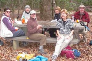
I did not hike this week so here is the Hike Report by Talley.  Thank you Jeff Catlin for permission to use your photos.

There’s one main reason to do this report and that is to let everyone know that this is a very good Spring wildflower hike.  And there is a waterfall, we just didn’t see it.  As we changed the day this week we only had Jeff, Harry, Alan and myself.  The trail starts at the fish hatchery

Fish Hatchery

Fish Hatchery Photo by Jeff Catlin

and makes a large loop with a “U-shaped” trail in the middle which takes you up 1000 feet to pop out on John Rock and get a magnificent and breezy view of Looking Glass Rock and the surrounds.  One can also see parts of the Blue Ridge Parkway poking out through the trees.  Yes, it is quite steep and strenuous.  There are lots of roots criss-crossing the trail.

Lady Slippers

Lady Slippers Photo by Jeff Catlin

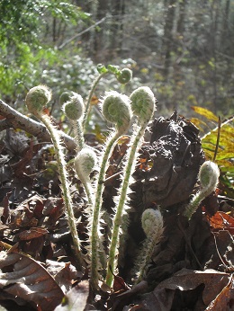
We didn’t think of it ahead of time as a wildflower walk but there were all kinds of trilliums, foamflowers, Lady Slippers, violets, Clintonia, wild geraniums in drifts, ferns and many others.

Trillium

Trillium Photo by Jeff Catlin

Jeff heard loads of different birds.  Jeff, I think the trillium with the nodding flower with maroon anthers is a Southern nodding trillium.  We saw lots of Vasey’s trilliums but I think the ones with the maroon flowers on top were Southern Red trilliums.  There were lots of other flowers but I’m lazy today.  This trail is definitely worth visiting in the Spring.

I would also like to revisit it in the Fall when the colors are out.  To this end I studied some websites as I found the trail quite confusing.  I learned that most folks do this one counterclockwise, starting down by the information building which is no longer a gift shop.  (We started at the other end of the parking lot.)  I suspect that either way the John Rock loop in the middle is just as steep.  There is a waterfall at the beginning of the trail which requires a quarter mile trek (one way) to get down to Cedar Falls.  The falls spur takes off to the left.  We started at the other end and climbed up to John’s Rock and then climbed some more to reach the top of this trail at 3300 ft.  When we finally stopped climbing we came to an intersection and followed the sign to the Parking lot and in so doing missed half of the trail and turned it into an out and back hike instead of a loop.  For those who are interested, here are the links.

This first link is very descriptive and takes the trail clockwise as we did. http://internetbrothers.org/2012/09/26/cat-gap-trail-to-john-rock-pisgah-national-forest/

The next has an interactive map which helps clarify the trail course.

This last is where Harry got his map, I think.

I’d rate this a 7.  We spent 4hrs and 15 min including lunch on the rock.  Because of the way we did the hike it’s hard to say how long it was but I’d guess about 6 miles.

HH Hikers

HH Hikers

Talley

Finally, we are back on the trail.

This Happy Huggers Hike Report brought to you by Talley.

Twin Falls trail that is.  This was a short and easy hike and it’s a good thing because it turned into a wildflower walk.  Twin Falls did not disappoint.

Photo by Alan

Photo by Alan

Seven of us met at Holly Springs: Harry, Alan, Laura, Linda Lee, Marina, Chris and yours truly.  Up 178 and bear left onto Cleo Chapman at the “Road kill Grill”.  It started out cool and refreshing for short sleeves but soon warmed up enough.  Just like last year, the flowers and interesting plants started immediately.  It was hard to get 10 yards without finding something else to examine.  The best way to do this report is to talk about what we saw.

Photo by Linda Lee

Photo by Linda Lee

I’ll start with the ferns and pardon me for the common names.  Right away we saw large Spring fresh Christmas ferns with their fiddleheads still unfolding.  Broad Beech ferns were everywhere as well.  A little further in we encountered New York ferns with their pinnae getting shorter and shorter as they marched down towards the base of the stipe.  In close proximity we found Resurrection ferns on tree trunks and small amounts of polypody on rocks.  Even further in toward the top of the falls we found Lady ferns with their red stockings.  There are drifts of Northern Maidenhair (Adiantum pedatum) climbing up the sides of the hill.

Photo by Linda Lee

Photo by Linda Lee

It may sound like it was all ferns but there was so much else to see.  There were huge rocks and the wind was rustling the bright green leaves giving the day a yellow-green glow.  The trail is narrow in most places with the hillside climbing on one side and falling away on the other.  For the last half mile or so the top of the Falls is visible through the trees.  Old rusting rails from the railroad that was previously in here possibly for logging can be seen to the side of the trail.  Numerous steps and switchbacks make this a much easier hike than it might be.

Photo by Linda Lee

Photo by Linda Lee

 Now for the wildflowers.

Photo by Alan

Photo by Alan

Almost everything was blooming. Foam flowers were just about finished but the Fairywands were not.  We found Solomon’s Seal and False Solomon seal both in bloom.

Photos by Linda Lee

Photos by Linda Lee

One Solomon’s Seal was so large with several flowers from each node that we wondered if it was a subspecies but the books say it can grow up to 6 feet long and the multiple flowers are not unusual.  Tim Spira says that some plants have diploid chromosomes and some have tetraploid (2 sets or 4 sets).  He says the tetraploid plants tend to be the really big ones.  Go figure.

Once again we found lots of Squawroot.

Photo by Linda Lee

Photo by Linda Lee

Sweetshrub is in bloom and there are some really nice ones near the top of the falls.  We found a plant that looked something like a Mayapple but wasn’t shiney.  I think it was an Umbrella leaf.  There was lots of Robin’s plantain everywhere in bloom.  Mountain laurel is starting to bloom.  Leucothoe is blooming but Yellowroot is just about done.

Photo by Linda Lee

Photo by Linda Lee

I think the solitary iris was a Dwarf iris, not an Iris cristata.  The flowers look different.  There was a lovely dark maroon Jack-in-the-Pulpit in the crook of one of the switchbacks and a huge Vasey’s Trillium.

Photo by Linda Lee

Photo by Linda Lee

We also found Catesby’s, Sweet Betsy’s and T. luteum.  The plant with the tiny yellow flowers is probably Golden Alexander.  There were blackberries in bloom and numerous Sweet white violets.  One beautiful little Yellow Stargrass sheltering at the base of a tree.  We found what we think is a Basswood tree and Laura made very good friends with a Garter Snake and a bunch of mushrooms.

Photo by Alan

Photo by Alan

That’s all I can remember.  It was a lovely day and it was great to be back in the woods.  Hike was about 3 miles total and I’d rate it a 2.  We were back at Holly Springs at 12:30.

Photo by Alan

Photo by Alan

Talley

John’s Roc… no wait – Yellow Branch Falls!

This was a “bait and switch” hike because the night before we decided to forego John’s Rock because of temps in the 30’s with wind advisory posted.  Although we were all toasty at our picnic lunch, the weatherman noted that Thursday afternoon while the temps were 60 in Greenville, they were 30 degrees colder in Asheville with 44 mph winds.  Indeed, shortly after we got home the arctic blast made it over the mountains and the temp dropped from 50 to 35 in no time.  Anyhow, that was the weather report, now here is the hike report.

Once again we had 7 hikers: Harry, Alan, Laura, Karen, Linda L. Marina and me.  We met at the YB parking lot and actually started moving at 10:00.  As we started out we were actually on the Nature Trail for 0.2 miles.  We were soon enveloped in Rhododendrons and Mountain Laurel. The trail was somewhat narrow and greener than most at this time of year thanks to a carpet of Galax.  We reached a point where the trail either headed to the right and down or continued straight and bent to the left.  I think that is the intersection of the Nature trail and the Yellow Branch trail.  As we hiked along the creek ran right next to us on our left and we had several stream crossings to make but all were on rocks and were easy, Brenda.  This trail encompasses many different habitats.  We soon reached a rather flat open area with many large old trees.  We saw white oaks, poplars, hickories, a large gum tree and lots of tired looking Christmas ferns just holding on for Spring.  The trail undulated up and down and right and left and we didn’t realize until the way back that we had been going downhill to the falls.  There is lots of downfall but one especially large tree which had been difficult to climb over in the past has been cut so it is easy to pass through.  There are many places where the trail narrows to almost nothing and the ground falls off to a ravine below.  We crossed several wooden bridges and at one we spotted a patch of green which Marina identified as “liverwort”.  A close look with the loop was most interesting.  Now I know what you meant by “hepatica”, Marina.

Photo by Karen

Photo by Karen

Before we could see the falls we could hear it and then all of a sudden there it was.  It is 50 feet high with huge rocks at the bottom and a ledge type falls in front which drops about 6 feet into a fairly still pool.

Photo by Karen

Photo by Karen

Alan and the mushroom hunters climbed all over the rocks at the bottom but Alan thought it difficult to photograph as have other photo-bloggers.  There was plenty of water to enjoy.  I have seen more and I have seen it be almost a trickle.  It was only 11:10 so we snacked and waited for lunch for our return to the Yellow Branch Picnic area.  On the way back we did find some signs of Spring.  Alan got the beautiful photo of the open Trout Lily.

Trout Lily by Alan

Trout Lily by Alan

We found some violet leaves and at least one violet.  No sign right now of the Grass of Parnassus which we know is there but we did find more Trout Lilies right near the same stream crossing.  We found a warm sheltered picnic table and enjoyed lunch, brownies and sunshine and met a local fellow who thinks he knows the reason it’s called Yellow Branch creek.  It had to do with local boys getting rid of their beer but I think he was pulling Yankee legs so I’m gonna forget about it.  Last stop was a quick look at Issaqueena Falls and then home to make more brownies since I had taken them all on the hike after hiding them from Bill.

This weeks HH Hikers

This weeks HH Hikers

I rate the hike a 3.  We started at ten, lingered at the falls, then had a leisurely lunch and were back in the cars by 2:15.  We were in no hurry.  Total mileage is only 3 miles.

Hike report by -Talley

Keowee Toxaway Park

Despite predictions of snow flurries and sleet in the mountains of NC, the seven dwarfs (Marina called us that) headed out to explore Keowee Toxaway park.  Hikers were Harry, Alan, Karen, Linda L, Lydia, Marina and yours truly.  “Hi ho, hi ho it’s off to work we go….”  No, really, we’re not, not any more.  We took the easy way around heading down to Poe Creek first, leaving the Natural Bridge for the end.  The patch of white Partridge berries is still there.  Guess the birds like the red ones better.  The day started out overcast and a little cool but as we began our gradual climb over Mt McKinney we started to peel layers.  Before long we could hear the groundsmen working on the golf course at The Cliffs.  And soon the big blue lake came into view.  We passed the two huge old Beech trees in a cove near the water’s edge and noted all the smaller beeches still holding on to their golden brown leaves.  We seemed to be followed by the calls of a Pileated Woodpecker across both sides of McKinney Mtn.  I don’t usually look up the birds but here goes…he is our largest woodpecker by far.  He excavates long oval holes up to several feet long in tree trunks and you can sometimes find the wood chips in a pile at the foot of the tree.  When you hear him drumming on hollow trees, branches, or even chimneys he is announcing his territory.  I’ve often heard that sound in my woods.

 Eventually we came to the turn off for the primitive camp sites.  Down on that little finger of land the wind really started to blow.  Back on with the clothes, hats, scarfs, etc.  We had lunch rather quickly and headed back. As soon as we got back on the trail we were sheltered by the land contours and no more wind.  The rest of the trail is gradual ups and downs, around the mountain and back to the Natural Bridge, a huge rock which spans Poe Creek.  It’s still a pretty good grade up from there back to the cars with a short stop for Karen to try out the balance beam bench after the climb.  Forgot to say the second half of the hike was sunny and gorgeous.  We were back at the cars at 12:45.

keowee_toxaway_hike_2-5-2014

I’ll give this a 3.  It was only a little over 4 miles.  So glad I went.  Thanks Harry for leading and Alan for sweeping.

Talley

The Narrows—-Eastatoe Gorge Falls

Today’s Hike Report by Karen Schneider

The Narrows—-Eastatoe Gorge Falls @ Pickens  County SC Located off Hwy 178 just past the road to Sassafras Mountain @ Rocky Bottom.

5 Hikers: Harry, Laura, Linda, Marina and Karen

Weather: mostly clear skies—cold start with wind out of SW, warmed up and partly sunny and slightly sleeting.

9am – meet @ gas station @ Hwys 11 & 178

car pool drivers were Harry and Karen.

Laura was with me (Karen) following Harry….that was until we turned off 178 onto Laurel Valley Rd. and going around one of the hairpin curves I spotted white mushrooms on a log that required closer inspection.

image3

Sure enough they were Oyster mushrooms that Laura scrambled down the log to rescue. They were a little frozen but still fairly fresh and edible. Now we knew Harry must have thought we got lost or drove into a ravine so we had to leave some furtherer down the tree for later and try to catch up.

We must have arrived at the parking lot around 9:30 and yes, Harry had turned around and thought he has lost us but as it turned out he turned around to go back to the big parking lot.

 After assembly, head count & inspection of our booty we did finally depart for trail head trudged on down toward the Narrows.

image4

Around 11:30 we arrive at old camp site area along Eastatoe Creek for rest & snack.

image1

After our break we made our way around the narrows and up the mountain to view gorge/falls & eat lunch.

image2

Around 12:15 pm headed back up the switchback trail returning along same route toward parking lot.

Although it was cool eating lunch by the gorge on the climb back we started shedding some layers.

We discussed the giant Cracked capped polypores and how they looked like steps going up the tree or balconies for squirrels to dine on walnuts. About 2/3 of the way back up we encountered some light sleet although the temp was around 48 – 52.

image5

At one rest stop I found 2 large Cracked Caps on the ground that must have been shaved off by a falling neighboring tree.

2:15 pm arrived back @ trail head p/lot area to retrieve cars and discuss plans to get more oysters on our way out.

I thought for sure we were going to loose Laura down the ravine this time! Fortunately for all we got the goods, divvied them up and headed back to the gas station meeting site.

 2:20pm arrived at gas station to retrieve cars, hug and head home.

Thank you for leading Harry.

Hike report by Karen Schneider

Winding Stairs Trail

Eleven of us finally managed to get out to hike on the first dry Thursday in weeks.  We caravanned from the Marathon station just South of Rte 130 on Hwy 11 to the trailhead hidden away down Cheohee Rd by Lake Cherokee.  For future reference I will include Brenda’s excellent directions to reach the trailhead:   Turn right at the Marathon Station onto North Little River Rd and watch closely.  In 0.3 mi turn left onto Whitmire Church Rd.  (The sign is hidden by bushes.)  Go about 3 miles to the intersection with Cheohee Valley Rd, turn left and immediately turn right onto Cherokee Valley Rd.  Follow this being careful not to be tricked into turning until you can turn right onto Jumping Branch Rd.  Follow this partway around Lake Cherokee to a green street sign for Cheohee Rd.  Bear right onto this gravel road and follow it a couple of miles to a parking area signified by a bunch of boulders on the left where Harry puts on his boots.

 Now that we are at the trailhead and Harry has his boots on we head up the Winding Stairs trail which will take us over Chattooga Ridge for an elevation change of 1100 to 1200 ft.  We noticed young hemlocks and clubmoss and Dog Hobble but no wildflowers as expected.  We noticed lots of dead pine trees which my hiking book says were wiped out in 2000 by the pine beetle.  Whole tall trunks were stripped of their bark and broken off at the top.  Early in the hike we came to a fallen tree which many of us circumvented.  Looking back from my spot behind Harry it looked like so many brightly colored creatures swarming through the woods, some crawling under and some crawling around the deadfall.  The trail heads steadily up at a mild grade for about a mile until the pitch increases and the switchbacks start.  These are long sweeping switchbacks taking us towards and away from West Fork Townes Creek.  Near the top of the switchbacks Miuka Falls is visible on the right and Chris and Kate had Alan take a great mother/daughter photo in front of the falls.  The climb is not too stressful but we all needed to shed some clothes as it was certainly enough to warm us up.  The sun peeked through from time to time and the view in the distance of Lake Cherokee was pretty with all the leaves down.

 At 3.4 miles we came to a fork in the road.  Taking the right fork soon took us to a picnic area at the Cherry Hill Campground.  (The left fork goes to Rte 107).  There we lunched at the cold concrete picnic tables and after about a half hour we were all ready to get going again to warm up.

image005

image006

Chris provided the two highlights of this hike.  The first was meeting her daughter Kate.  Lucky Chris had her own Sherpa to carry her pack up the “stairs”.  The second highlight was in the pack—Chris’s famous chocolate chip/banana muffins, little bitty things with very few calories. J

The hike down was a walk in the park and by 2:30 we were back at the cars and following our breadcrumbs back to Hwy 11.

Hikers were: Harry, Alan, Brenda, Laura, Karen, Linda Lee, Marina, Lydia, Chris, Kate and yours truly.

Miles: a little over 7;  time: 10:00 to 2:30 with 30 min lunch.

Hike Report by:  Talley

Ashmore & Eva Chandler Heritage Preserves

Photo by Brenda

Photo by Brenda

As 6 bundled up HHHs’ parked on Persimmon Ridge Rd. at Greenville County’s 1,125 acre Ashmore Heritage Preserve  11/20/2014 they were greeted by a friendly yellow Lab from a nearby home.  The dog seemed to have met his calling on this day as he took to the trail running in front of Harry, Linda Lee, Laura, Brenda, Karen, and Alan, seemingly saying ‘Follow me, I’ll show you the way to Lake Wattacoo.’ He was an excellent guide (giving Harry the morning off as hike leader) for within half an hour after making a stream crossing at West Fork Cr. and ambling along the gravel strewn trail we (and the dog) arrived at the picturesque, 5 acre Lake Wattacoo. The pitcher plant beds along the NE shore of the lake are dormant this time of the year but will be in bloom in the coming spring.  A single blue gentian plant was growing between the shore and the path around the lake.  Campbell Mountain rises to the north and  standing on the dam and looking at the mountain, to the right Ashmore Falls can be seen cascading down the granite face and eventually flowing through the woods into the lake.

Photo by Karen

Photo by Karen

Leaving the lake, the trail is mostly flat, passes through a patch of more blue gentian and crosses West Fork Cr. again but this time by a metal footbridge and begins a few minutes descent to Persimmon Ridge Road and a short walk to our cars-and a ‘Thankyou and Goodbye’ to our guide dog for the nearly 2 mile saunter.  From Ashmore HP we drove further up Persimmon Ridge Rd. to Eva Russell Chandler Heritage Preserve and parked on the road where Slickum Creek crosses beneath. We followed the clear flowing creek through a open wooded area abundant with ferns. About a quarter mile from the road the creek becomes Slickum Falls as it flows down the left side of the sloping rock face disappearing into the woods and granite below.   To the right and down a ways on the rock face is a small

Photo by Karen

Photo by Karen

patch of mossy vegetation and a few sturdy and healthy Eastern Red Cedar trees-a perfect spot for an early lunch and to enjoy the rolling scenery before us. On the horizon Paris Mountain and buildings in downtown Greenville are visible to the southeast . The Chandler Preserve may be known for its Divided-Leaf Groundsel and Grass-of-Parnassus but these rare plants  proved elusive to us on this trip.  Karen, however,  spotted a Swollen-stalked cat mushroom as we neared the end of the day’s second hike. Maybe someone will find some information about that lonely fireplace and chimney standing in the woods of the Chandler Preserve.

Photo by Brenda

Photo by Brenda

     A perfect day to enjoy the out of doors even if we hiked maybe 3 miles.  A rating of 2 seems appropriate considering the gravelly section of trail and the stream crossing.

* This weeks Hike Report brought to you by Alan.

Palmetto Trail, Oconee Connector

This week we took the hike that we cancelled for inclement weather last week.  We began with a walk to Station Cove Falls which looks different with so many leaves down, somehow more like a winter scene than the lush wildflower strewn place we are used to from Springtime hikes.

Photo by Brenda

Photo by Brenda

We posed for the first of several group shots and then returned to the turnstile with the sign pointing to Oconee State Park, 2.7 miles.

We climbed Station Mountain via a series of switchbacks until we noted that we were on a gradually ascending ridgeline with a gravel road under foot.  The trail was covered with fallen leaves and when the wind blew the leaves rained down from the red and yellow canopy.  The leaves, however, were not deep enough to cause trouble with footing.  There are enough leaves still up that we were denied the impressive views to the North which sometimes add to this hike.

Photo by LindaP

We continued trudging along following the yellow slashes with the dot on top.  We located a geological marker at 1633 feet above sea level

IMG_4383

and knew we had about 100 more feet of elevation to gain.

At the 2 mile marker we met a couple who had already been to the point where the Foothills Trail crosses the Palmetto Connector and had noted signs for Hidden Falls and Tamassee Knob.  They had turned back to return to Oconee Station and asked if we knew where the gravel road would take us.  Now, this is what literature professors call “foreshadowing”.  For future reference, the 2 mile marker is situated right next to two large rocks ideal for sitting which is where we found these hikers relaxing.  We continued on and just about the time we started to see signs on the trees marked “ Oconee State Park boundary” we found a trail crossing our trail and this is where the Foothills Trail crosses the Palmetto Trail.  We noted a yellow slash a few feet down the gravel road and continued on the road.  The second small trail marker that we came to on our left marked a small trail heading off the road and into the woods.  There is a small tree right next to the sign which carries a faded yellow slash and we later learned that this would have taken us to the picnic tables we were headed for that we remembered from our last trip up Station Mountain.  Instead, we soldiered on on the wide, gravel road thinking the Palmetto trail would come back to the road.  This is how we found out where the gravel road goes—all the way  to Hwy 107, about a mile past the entrance to OSP.  We also found out that Chris can come up with a marching song for any occasion.

So there we were, at Oconee State Park with indoor (flush!) plumbing, a ranger-manned office, a cooler full of ice cream and don’t think that wasn’t tempting.  A sign on the road pointed the way to the Palmetto Connector so after availing ourselves of what the park had to offer we set off to find the OSP end of the Palmetto Oconee Connector.  After about a mile walk up a winding asphalt road we came to a small parking area on the left and a kiosk by the roadside.  A sign in the woods said “Chestnut Hill Trail” but we were looking for the Palmetto Trail.  But wait, there was a yellow slash on a tree and another further into the woods along an ill used trail.  We decided to follow the slashes and rather quickly came upon the rock wall and the picnic table which we had used on the last hike.  Now we knew we were on our way back toward Oconee Station on the Palmetto Connector.  This is a fairly lengthy meander through the woods remarkable for a bog surrounded by clubmoss and providing a pseudo-stream crossing on small logs lying in about 6 inches of water.

photo 3

Eventually we came out on the gravel road again and followed it as it porpoised up and down over Station Mtn.  Once again we passed the intersection with the Foothills Trail and could look into the woods on our left and see signs pointing to Hidden Falls, Tamassee Knob and the FT.  We continued on past the big rocks and the “2 mile” sign and eventually reached the comfortable footing of the switch back part of the trail.  We were happy to see the “turnstile” leading to Station Cove Falls and happier still to see our cars after that last ½ mile.

Still smiling after Ten Miles! - Photo by Karen

Still smiling after Ten Miles! – Photo by Karen

Sorry for the exhausting detail but since we have not traversed OSP before on foot I thought it would be good to describe how to find the Palmetto Connector from inside the park and to describe the landmarks along the way. The one interesting botanical find was large canebrakes of native bamboo in OSP.  This may well be Arundinaria appalachiana which is a species separate from switchcane which is more common in the Piedmont.   I’m running out of space.  We hiked from 10:00 to about 3:00 and estimates varied from 10 to 11 miles.  Harry could have done it much faster without us.  I rate this one a 5 the way we did it.  Hikers: Harry, Brenda, Linda P., Chris, Lydia, Karen and yours truly.  Thanks Harry for the adventure.

LindaP note:  It was an adventure!  I had my Whiners Card out because I dropped my pacifier but for all my crying it was a beautiful day for a hike.  Thanks Harry!  

And as always thank you Talley for the Hike Report.

Photo by Karen

Photo by Karen

Wintergreen & Hooker Falls – DuPont Forest

*Text for this blog post taken directly from Talley’s hike report

Happy Halloween, Ya’ll.  10 Huggers hiked Dupont Forest to find a cemetery to celebrate Halloween.  Actually, we found two, cemeteries that is.  Harry led us on this gentle hike over the sandy trails of Tarkiln Branch on a gorgeous sunny, cool day.

IMG_4263

We’ve done this before but this time we took the trail to Wintergreen Falls along a lovely rock filled creek.  The last hundred yards to the best view of the falls is a bit of a scramble but with helping hands there were no mishaps.

Wintergreen Falls

Wintergreen Falls

Once we were done ogling and photographing the falls Harry headed us toward the Thomas Family Cemetery.

Thomas Cemetery

Thomas Cemetery

Jeff’s photos (on Facebook) show how we scattered ourselves around the cemetery, lounging on fences and stumps and examining gravestones.  The lunch conversation did become appropriately ghoulish with discussions of final arrangements and burial wishes and particularly Laura’s reasons to avoid cremation (sorry, you had to be there).  We passed around treats and reluctantly got to our feet when Harry felt it was time to move on to keep on schedule.

 We shared the trails with lots of leaf peepers.

IMG_4292

Btw, not all the leaves are down but on the NC side it was past peak.  The best color was to be found as we descended 276 from Caesar’s Head.  I bet today all of that is covered with heavy wet snow.  Two large groups of horseback riders were on the trails, one all the way from Ohio.

IMG_4280

 On the way back we stopped at Hooker Falls

Hooker Falls

Hooker Falls

and the Moore family cemetery.

Moore Family Cemetery

Moore Family Cemetery

The cemetery was interesting in that it was almost entirely carpeted with club moss.  Once again we found lots of very old gravestones to examine.  We encountered bicyclists and even a lady in a motorized wheelchair.  Yup, Hooker Falls is wheelchair accessible.

OK, a short botanical discussion.  We rediscovered the Allegheny blackberries that Brenda ID’d last year.  We discussed how to tell fir trees from spruce.  On Fir trees the pinecones stand up and on Spruce trees they hang below the branches.  Linda Price found some tiny little “cones” which were undoubtedly from hemlocks.  The whole pine cone is no more than ¾ inch long at maturity and wide open so they don’t depend on fire to open like the Table Mountain Pines at Ninetimes.

IMG_4290

Laura Found Honey Mushrooms

IMG_4284

Natural Tree Chair

Photo by Brenda

Photo by Brenda

Hikers were Harry, Alan, Jeff, Linda P, Linda L, Laura, Karen, Brenda, Lydia and me.

Mileage was 5.5 by the Dupont map.  Timing was irrelevant with all the trick or treating and hanging out in parking lots.

 Thanks everyone for a fun Halloween hike.  Jeff and Karen, it’s great to have you back.

Talley

Moonshine Falls Hike – April 2014

…..Somehow I missed adding this hike from last Spring here…..

We were 8 and 2—Harry, Alan, Rebecca, Brenda, Terry (Welcome), Lydia, Marina, Linda P, Laura and myself.  We entered through Asbury Hills United Methodist Church Camp off 276 and started off on a short gravel road which went as far as the lake.

IMG_3093

We then ascended a half mile which was fairly steep and scrabbly with rocks.  After that the trail leveled out and had only gentle elevation changes until the final short and steep descent into the moonshiner’s cave and Falls.  In a nutshell, this hike was wildflowers, cables, and lots of water and rocks.  The path as far as the cables was wide enough to “walk and talk” and lined on both sides with all kinds of violets.  Easily identified were the Long Spurred Violets.

Long Spurred Violets

Long Spurred Violets

We found common blue violets, sweet white violets, Halberdleaf and others.

IMG_6863

Christmas ferns have put up their new fiddleheads

Photo by Alan

Photo by Alan

and NY ferns are shiney green and new.  There were lots of sessileleaf bellworts also known as wild oats.  There were still some bloodroots blooming and dwarf crested irises were blooming everywhere.  There were Rue anemones (Brenda, did we see regular anemones as well?).  Brenda found some blooming trout lilies while half of us were exploring the Moonshiners hang-out.  Mayapples showed us how only the plants with 2 leaves will bloom.  There were flower buds hidden under the leaves at the bifurcation.

So then we reached the cable crossing.

IMG_6871

Brenda and Rebecca felt they had been there and done that enough times before.  Lydia, Marina and Terry decided to join them to hunt wildflowers, lounge around and maybe draw or watercolor while Harry, Alan, Linda P, Laura and I crossed the cable to go on to the Falls.

Photo by Alan

Photo by Alan

I guess it took us about a half hour until we came upon the rock cairns

IMG_3065

and Dean’s festive orange ribbon which marked the turn off Naturaland Trail to the Moonshiners Falls.  We crossed a couple of small streams and continued to see lots of wildflowers.  It is still a little bit of a scramble down to the falls

IMG_3069where we found the 50 gallon drums that supposedly used to hold moonshine.

IMG_3070

We could picture the moonshiners having a good old time under the huge rock overhang

IMG_3074

over which pours the falls cascading to the pool below.  Alan got a spectacular photo of Linda risking her neck to get a photo of the pool.

Photo by Alan

Photo by Alan

Linda, Alan and Laura went down to investigate the pool

IMG_3077

and after a well-earned lunch we started back to join the others.

IMG_3072

I should mention that we found bluets scattered among the rocks in the cave and blooming yellow root hanging, back-lighted, from the lip of the cave.  After some slight confusion at some streams we thought we had not crossed before we returned to the cable crossing.  To this point I was refusing to think about the fact that Alan had pointed out that the cable is attached on one side to a dead pine tree.  UH-OH—  Maybe Brenda and Rebecca knew something I didn’t know.  On the way back we explored Cascade Falls which is a ledge with water pouring over it and a swimming hole which was very inviting.

Cascade Falls

Cascade Falls

So we returned to Asbury Camp and took our group photo.

photo by Alan

photo by Alan

Asbury Camp, BTW, is a 1900 acre property protected in 2007 through a Conservation Easement granted to the Nature Conservancy. Good to know as it is certainly beautiful.

We started at 9:20 and returned by 2:30.  Distance was 5 to 6 miles. I would rate it a 4.  Thanks Harry for leading and for the banana bread.

Talley

I promised to explain “stemless” violets.  Some violets have basal leaves and hold their flowers on a separate stem.  These are called stemless.  This terminology is found in the Tennessee wildflower book.  There were spots where we found “stemless” and stemmed violets (flowers and leaves come from one stem) growing side by side.